County Clare, Ireland, is best known for the Cliffs of Moher, the ancient dolmen of Poulnabrone, and its rich musical heritage, but it offers many other fascinating sites and, most importantly, the hospitality and warmth of the people in the villages. My wife Betsy and I traveled across the country one January from Shannon on up, down, and across to Dublin, seeing many memorable sites and having the pleasure of meeting many warm and welcoming people. When I think back on the trip, however, the memories which linger longest are of the lovely village of Doolin where we spent our first weekend.
Ennis
We landed at Shannon airport in the dark of early morning and took the rental car to the medieval town of Ennis. It was raining lightly, and the city streets and sidewalks shimmered in the haze from the streetlamps. Winding through the silent city in the pre-dawn darkness, we crossed over a stone bridge above the River Fergus and parked near the Franciscan friary. This lovely building dates from 1250 CE and was closed, along with all the other Catholic institutions, under the reign of Henry VIII (r. 1509-1547 CE) during England's Protestant Reformation.
We wandered the streets in the twilight of morning until the shops opened and we found a warm café for breakfast. Ennis is a beautiful village and felt crisp and clean in the morning light, stone bridges arching over the swiftly running river. We both would have liked to spend more time there but we had to move on and so headed for Doolin and our first planned stop at the Cliffs of Moher.
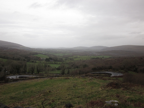
The journey up through the hills of Doolin toward the sea is an adventure all on its own. The roads are the typical Irish rural paths where you're certain two cars cannot possibly pass each other without colliding. There are ruins of old stone houses and churches interspersed among the new homes of concrete or sitting alone out on green hilltops and low pastures.
The Cliffs of Moher
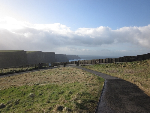
Upon arriving at the cliffs, one must pay for parking and admittance, 6 euros per person, in cash - no credit cards accepted. The wind was howling across the parking lot when we stepped out of the car and we struggled against it toward the visitor's center.
Inside it was comfortably warm out of the wind. There is a short film on the history of the cliffs and exhibits, restrooms, a cafe, and gift shops. We were eager to go see the cliffs, but the wind was so cold and so fierce, coming off the sea at 80 km (50 miles) an hour, we needed some time to warm up and so watched the film and explored the exhibits. Heading out the doors for the cliffs, security personnel cautioned us not to venture too close to the edge; there was a very real risk of literally being blown away.
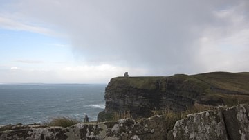
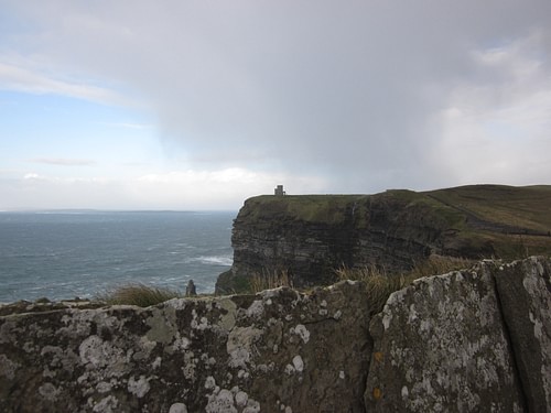
The Cliffs of Moher are justly famous, rising 214 meters (702 feet) from the sea which beats against the base and sends spray flying into the air. We pushed on against the wind up the broad, stone stairs toward O'Brien's Tower at the top. The North Atlantic rolled in white surging waves far below us and, all along the coastline, we watched them breaking loudly against the rocks. Sea birds flew up in great circling flocks and the day was so cold that the water froze into tiny white sparkles mid-air and then scattered as ice across the walkway and stairs.
The word 'exhilarating' does not even come close to describing the experience of the Cliffs of Moher in January. Standing with Betsy at the top of the stairs, the sea spray in the wind lashing at us, looking down at the rolling waves, I felt as though I were in another world, a greatly elevated world, where every sensation seemed sharper, the light brighter, each sound more resonant.
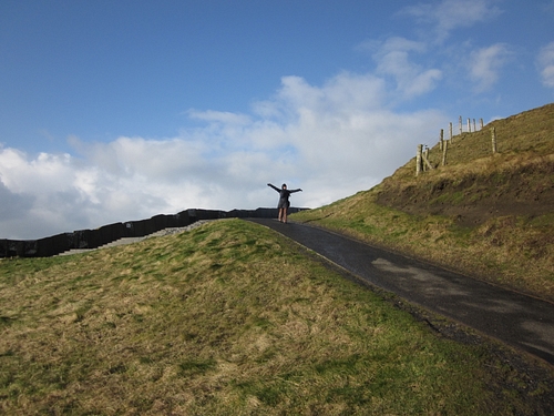
The lowest point of the cliffs is Hag's Head at 120 meters (390 feet) where the old 18th-century CE fort once stood which gives the cliffs their name. The Moher fort was destroyed in 1808 CE for building material but, by that time, the name had attached itself to the cliffs. We were standing at the highest point, near O'Brien's Tower (built in 1835 CE), and it seemed as though one were standing at the very top of the world. That sensation became increasingly perilous with the winds, however, and so we descended and walked over toward Hag's Head. The wind was no less strong at the lower elevation, but we almost did not mind it for the magnificent view of the sea and O'Brien's Tower high on the far cliff we had just come from.
Doolin Pier
We finally said goodbye to the cliffs and drove on through the countryside, stopping in the 19th-century CE town of Lisdoonvarna where we walked the streets and stopped in a few shops. The town takes its name from a Celtic word for "fort of the fairy hill" and this is well chosen because the entire place resonates with a Brigadoon-like quality as though it could vanish away any second into the fairy realm.
From Lisdoonvarna, we went on to Doolin, where we would be spending the weekend, and passed by the striking 14th-century CE Doonagore Castle, high on a hill overlooking the sea. Today this is a private holiday home, closed to the public, but well worth stopping to view from the road.
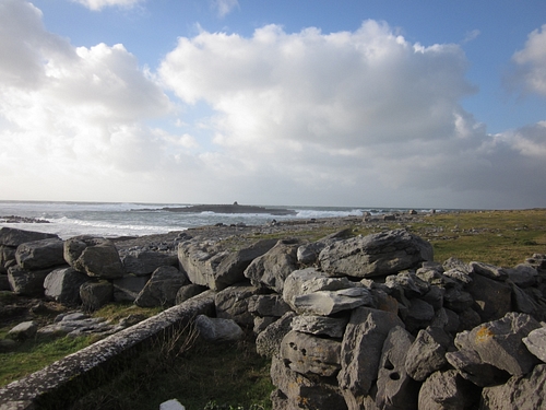
We drove down the hills and through the narrow streets of the town to Doolin Pier where you are face-to-face with the sea right at your feet. The waves blasted themselves in enormous sprays of white against the rocks of the shore while the winds tried to bend us backwards.
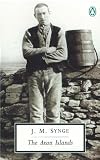
In season, I was later told, this is a popular spot for surfing, and I could easily understand why as the waves are enormous. Out among the rolling waters, we could see the smallest of the Aran Islands seeming to bob in the sea. From this point at the pier, or close to it, the Irish writer John Millington Synge would have departed for his stay out on the Arans where he produced his "first serious piece of work", as he called it, The Aran Islands, published in 1907 CE. The Aran Islands is my favorite of Synge's works and it was a grand thought to consider how I was walking where he had, seeing the sights he might have seen, but then the wind came on even stronger and the sea spray was actually freezing on our coats so we retreated to the car.
The Killilagh Church & Doolin Village
We made our way back through town toward the Churchfield Bed & Breakfast. Doolin is a fascinating village of four distinct sections: the harbor (close to where we were at the pier); Fisher Street (where one finds most of the shops and pubs); Fitz's Cross (another commercial district), and Roadford, the most rural area of the village where we would be staying.
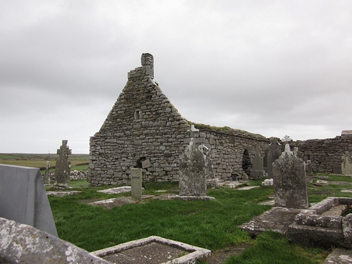
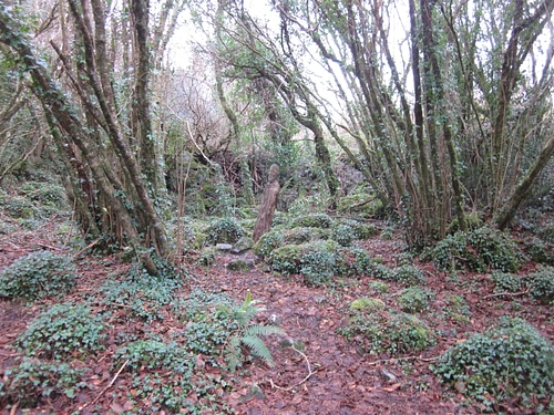
Churchfield B&B was on a slim path of a road near a stone bridge over a part of the Ailee River which runs from the rocky Burren region above town down to the sea. On the far side of the building, far out toward the horizon, the ruins of a stone building, the Killilagh church, rose from a field – hence the name.
My favorite part of our stay in Doolin was the time spent with people in the pubs and shops and at Churchfield B&B, taking our ease after a day, and talking about life. I especially enjoyed hearing the history of the village from Tony McGann at a table in his pub, sitting by the fire, a group of musicians playing in the corner, and our hostess Maeve Fitzgerald's tales of life in the Burren as we sat in the comfortable warmth of her dining room.
If I were to select one image which symbolizes Doolin for me, though, it would not be a fireside scene; it would be the ruins of the Killilagh Church in the far field because it is still a vital part of the history of the people. It was referred to simply as "the old church" to differentiate it from the new one, not as "ancient" and not as a "ruin", but simply as older than the present church people attended - even though it was built in 1470 CE and was burned by Cromwell in 1645 CE. People still visit the Killilagh Church to lay flowers on the graves there and the old and new graves stand side by side in and around the grand old stone building. The ruined church seemed a symbol of the land and the people to me; still standing and enduring and beautiful no matter the challenges and troubles of the years.
Company & Conversation
There were two fine pubs down the road from us, but we favored McGann's and had an excellent dinner there of hot Irish stew in large bowls served with mashed potatoes and freshly baked bread. A few pints of Harp by the fire and the lovely tunes of the small band in the corner, talking with Tony McGann, rounded out the evening and we walked back to Churchfield in a kind of stupor of satisfied weariness.
After our adventures, I was prepared to sleep soundly but the winds of Doolin had other ideas. I understood completely that night how the Irish developed the concept of the shrieking Banshee. The winds screamed and seemed to latch invisible fingers beneath the soffits of the roof and pull. Every inch of the building seemed to moan and steel itself against the blasts.
In the morning, over a fine Irish breakfast, Maeve commented on the night winds which then led her to a history of the village and the early settlers who built in stone, the buildings still standing in a field just down the road. The town was deserted in the mid-19th century CE during the time of the famous potato famine which Maeve, like Tony the night before, characterized as more of a genocide perpetrated by the rich landowners on the poor tenant farmers.
The Burren & Poulnabrone Dolmen
After breakfast, while Betsy got ready for our day's journey, I walked down the road and out to the old village; silent stone structures standing vacant in the valley of a field under the shadow of a mountain. Normally I would have thought it sad all these people were gone and their homes deserted and in ruin but the stories I had heard made the silent village seem so alive because it was still a part of the communal memory.
I returned to Churchfield and we went off to explore the Burren. The Burren is what is known as a karst landscape made up of dolomite, gypsum, and limestone rock but no technical definition can do it justice. Walking in the Burren in spring must seem like strolling the Garden of Eden from the descriptions I heard from Maeve but, in winter, it seemed equally magnificent to us.
We stopped at the 17th-century CE Leamaneh Castle, home of the infamous Mary Rua ("Red Mary") who appears in a number of Irish legends and songs. Mary had over 25 husbands, all of whom died under mysterious circumstances. Known for her bright red shock of hair as well as for doing precisely as she pleased, Mary was considered a walking scandal to her neighbors who finally sealed her alive inside a hollow tree, believing her to be a witch. Her ghost is said to still haunt Leamaneh Castle today. The site is not open to the public and sits on private lands, but one may still get a good view of it, quite close, from the road.
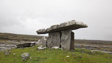
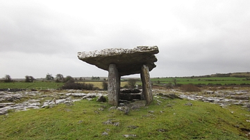
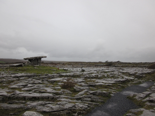
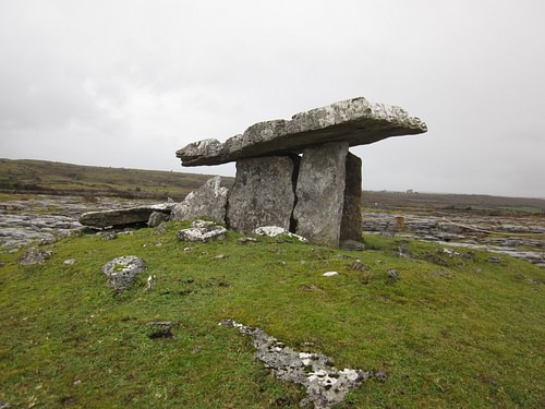
From Leamaneh we wound our way up through the slender roadways of the Burren, signs of civilization becoming less and less frequent, abandoned stone houses and distant towers far across the green fields giving way increasingly to the karst landscape. The narrow cattle paths we were on became a main road and we found the object of our day's trip: the Neolithic dolmen of Poulnabrone.
Dated to c. 4200 BCE, Poulnabrone stands 5.9 feet high (1.8 meters) and 12 feet (3.6 meters) long in a field surrounded by the karst stone formations which make up the Burren. A "dolmen" is a single-chamber, megalithic tomb defined by a capstone resting on two orthostats (upright stones). Poulnabrone is the best-known and most often photographed of the almost 200 dolmens in Ireland. I had heard that, in season, the site was regularly crowded, but one of the great advantages to Ireland in January is having such places entirely to one's self, and we spent considerable time walking quietly around the monument.
The handlers brought out a falcon and a hawk for the demonstration and invited Betsy to launch them from her arm. There was also a Great Sea Eagle and other birds there one would never normally see. After the demonstration we walked up a path toward the caves through the woods, periodically passing by fascinating Celtic art pieces in wood and a small shrine. We had a lunch of hot vegetable soup with brown bread and then took the tour of the caves.
These caves are the oldest formations in County Clare with calcite formations dating back 350,000 years. The cave tour began with us ascending as the guide told us the cave's history and pointed out various points of interest but then we started to descend into the earth. At one point the guide turned out all the lights, and we were in complete darkness. I could see nothing, and there was no sound save a faint trickle of water. At another point there was a waterfall, illuminated in pale blue light, accentuated by the darkness around it. The place felt so ancient. Down and down we went on these wooden ramps or concrete or stone inclines, and it seemed that every step led us further and further back in time.
Conclusion
Leaving Ailwee Caves, we stopped at the 10th-century CE Caherconnel Stone Fort - a fascinating site known for early metalworking - and then went on to the village of Ballyvaughan where we parked by the pier and got out to watch the sea beat at the shore. Ballyvaughan was first settled in the medieval period but the present-day village grew up in the 19th century CE primarily as a fishing port. Like Lisdoonvarna, Ballyvaughan has an ethereal quality to it and, as one of the locals said, "is known to be favored by the wee folk" for its natural beauty.
The day was drawing down toward evening and we headed back to Doolin. I had wanted to show Betsy the old deserted village but it was getting too late so we scheduled that for the next day before leaving. We instead located another side road near our B&B which led out toward Killilagh Church.
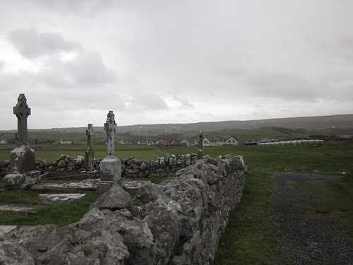
We visited the church and the cemetery surrounding it toward twilight, the wind from the sea whipping past us and the Cliffs of Moher in the distance, and the stories I had heard in the days we had stayed in Doolin became more alive and the images more vivid. I could feel the past and the presence of the people who had come and built this church and their village of stone and then vanished away but who still lived on through the stories of those who remembered and honored them.
Our time in Doolin set the standard we would experience in our travels all across Ireland of fascinating people, beautiful landscapes, and stories that weave the past and the present together as one. Yesterday's events are never forgotten in Ireland - no matter how long ago yesterday was - they live on in the memories and songs and stories of the people - who are always only too happy to share them with new friends.