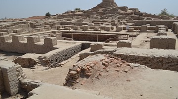
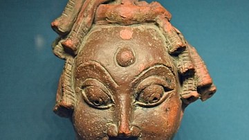
Harappa is a large village presently in the province of Punjab in Pakistan. The modern town is a part of and lies next to the ancient city. The site of Harappa is important in that it has provided proof of not just the Indus Valley Civilization as it was in its prime, but also of preceding and succeeding cultures as well and is the only site included in this category. The old path of the Ravi River runs to the north of the site, which has since shifted six miles further north.
It is speculated that its oldest mention is in the Rigveda, as the scene of the defeat of the Vrcivants by Abhyavartin Cayamana. The name is recorded as Hari-Yupuya. The previous inhabitants were presumably non-Aryans who were vanquished. Thus it might be said that this site is one of the famed sites where the so-called Aryans overcame the local population and established their dominance. However, until further proof is uncovered to support the theory, this is mostly conjecture.
The first visit to Harappa was made in 1826 CE by James Lewis, who was a British army deserter and roamed the Punjab and North West areas in search of antiquarian remains. On his journey to Multan he approached Harappa and had the following words in description for it, as recorded by Nazir Ahmad Chaudhry in his book:
East of the village was an abundance of luxuriant grass, where along with many others, I went to allow my nag to graze. When I joined the camp I found it in front of the village and ruinous brick castle. Behind us was a large circular mound, or eminence, and to the west was an irregular rocky height crowned with remains of buildings, in fragments of walls, with niches, after the eastern manner. The latter elevation was undoubtedly a natural object; the former being of earth only, was obviously an artificial one …The walls and towers of the castle are remarkably high, though, from having been long deserted, they exhibit in some parts the ravages of time and decay. Between our camp and it, (there) extended a deep trench, now overgrown with grass and plants. Tradition affirms the existence here of a city, so considerable that it extended to Chicha Watni, and that it was destroyed by a particular visitation of Providence, brought down by the lust and crimes of the sovereigns.
Lewis related the city to Sangala from the age of Alexander (1300 years previous) by which he was mistaken in his assumption. Later in 1831 CE, an emissary from King William IV, namely Alexander Burnes, recorded the extensive remains at Harappa while travelling from Multan to Lahore to deliver gifts of horses from the King of England to Ranjit Singh. He has also described Harappa while on the same route:
About fifty miles eastward of Toolumba, I passed inland for four miles to examine the ruins of an ancient city, called Harappa. The remains are extensive, and the place, which has been built of brick, is about three miles in circumference. There is a ruined citadel on the river side of the town; but otherwise Harappa is a perfect chaos, and has not an entire building: the bricks have been removed to build a small place of the old name heard by tradition fixes the fall of Harappa at the same period as Shortkot (1300 years ago), and the people ascribe its ruin to the vengeance of God on Harappa; its governor, who claimed certain priveleges on the marriage of every couple in his city, and in the course of his sensualities, was guilty of incest…I have found coins in these ruins, both Persian and Hindu, but I cannot fix its era from any of them.
However, their records were noticed by Alexander Cunningham, who visited the site in 1853 CE and 1856 CE, resulting in a small excavation in 1872 CE, which then identifies the site with that of Malii, which Alexander had ordered to be blockaded when he invaded the subcontinent. That city was near extensive marshes and to the east or south-east of Kot Kamalia, and Harappa lies exactly in such a place on the banks of the old course of the Indus and 16 miles east-south-east of Kot Kamalia.
The site even at this time was used as a brick quarry by brick robbers working on the Multan Railway, in the same way that Mohenjo-daro and Kalibangan became quarries for the Sind and Bikaner Railways respectively. During his excavations, Cunningham found pottery, chert blades, and a seal. Cunningham termed the seal foreign to India at that time. Also according to locals, the citadel hill was the site of a major Hindu temple that was destroyed and was at the time the site of a tomb of Nur Shah. Some artifacts were found with this tomb. The bricks taken from the site were more than enough to furnish 100 miles of the Lahore Multan Railway, testifying to the scale of the buildings that existed there. Despite several excavations, Cunningham found very little to preserve as the majority of the settlement had been stripped of bricks. Subsequent excavations at Kalibangan, Suktagendor, and Mohenjo-daro revealed the extent of this civilization, but it wasn't until 1922 that extensive investigations were carried out at Mohenjo-daro and Harappa and the corresponding sites were labeled as the Indus Valley Civilization.
John Marshal then sent a deputy, Harry Hargreaves, on an inspection of Harappa in 1914 CE to determine if it should be further excavated, and it was his work that allowed the acquisition of the Harappan mounds for further study. Further seals were found and similar seals were found in Mesopotamia which pushed the age of these sites beyond even what had been previously considered into the 3rd-4th millennium BCE and this was attested by Dr. Ernst Mckay as well who was working at Kish in Sumeria. John Marshal abandoned his Taxila digs to work on the sites in Harappa and Mohenjo-daro in 1923-24 CE and this is considered the point where the Indus Civilization is finally considered to have been identified. Other archaeologists who worked on the IVC at this time were Rai Bahadur Daya Ram Sahni, Madho Sarup Vats, Rakhal Das Banerjee, Ahmad Hasan Dani, Aurel Stein, and E. J. H. MacKay. Mortimer Wheeler then took over the excavations in 1944 CE and continued this into the post-partition era when he was archaeological adviser to the government of Pakistan. The later work of Dales, Meadow and Kenoyer specifically in Mound E has pushed the historical dates back to the early 4th millennium BCE.
Town Planning at Harappa
Harappa is located near the Ravi River, which is a tributary of the upper Indus region. The patterns of settlements were based on the behavior of rivers which is based around the flood plain ecology, regional trade over rivers, favorable climate for daily life, access to trade routes and natural resources, etc. Easy access to water table near rivers and arable land due to alluvial soil encourages human habitation. Cities like Harappa, which lie on the periphery of the known Indus Valley Civilization, served as gateway cities into the main region where that civilization held sway and were hence more robust or powerful than smaller cities. It is spread over 450,000 sqm of space.
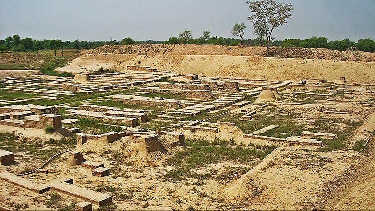
Ransacked by local housebuilders and mostly demolished during the 19th century CE construction of the Lahore Multan railway during the British Raj, the ruins at Harappa now stand in a fragile state but nonetheless still have a host of information to provide us. Most obviously what we see is the same general layout as at Mohenjo-daro in Larkana, Sind. The circuit of both cities spreads to about 3 miles, and both have the same differentiation of areas in terms of town planning as well. These areas can simply be divided into the lower (public) and upper (acropolis) areas. Both had the same shape where the acropolis is concerned namely a parallelogram that was 400-500 yards north-south and 200-300 yards east-west. The height is 40 feet from the flood-plain and both the cities are similarly oriented, with the major axis north-south. The grid plan is indicative of an evolved civil engineering principle that had developed at the time, which is not seen in the older towns of Mesopotamia such as Ur which have a meandering street layout that is more natural. Although the plan at Harappa isn't fully excavated, the general similarities mean that it was probably the same as at Mohenjo-daro.

Massive defensive walls on all sides have been partially exposed. Sections reveal post-Harappan cultures linked with Rana Ghundai to be at the very base of the structure, after which some time of no occupation is followed by a fully mature Harappan culture. A tapered embankment to protect against floods was made along the outer defensive wall as well. This was formed by filling up the previous alluvial deposits that had been washed away by rains with more mud bricks and mud. 6 variants of the internal plan are seen made using baked bricks and spreading over a considerable period of time. Bastions are seen at regular intervals as well with the main entrance seen at the north end. There is also an entrance to the west end next to a bastion. This leads to ramps and terraces outside the gates and supervised from guardrooms. Ramps are in evidence in many places and the existence of stairs is also known from the accounts of Alexander Cunningham but those stairs have been removed since that time by brick-robbers. The fortifications themselves have been built and rebuilt even in antiquity, first utilizing simple brick bats and once those had worn down they were replaced nearly from the ground up by baked bricks of refined Harappan style.
The cities of the Indus Valley all have a number of common factors that distinguish them from the civilizations of the Bronze Age. The defining feature of overall town planning of the cities is the cardinal orientation, with the longer grid aligned north-south to take advantage of prevailing winds. The layout and compartmentalization of the cities look to have a visual and conceptual connection to the geometric designs on seals from the Early Chalcolithic and even the houses of Mehergarh and perhaps if not directly connected, there is probably indication of a cultural template for the organization of space that continued to form a basis for cultural styles and patterns in the Harappan era. This organization of space into grids is seen not just in town planning in this area but also in house plans, designs on pottery, diagrams on seals, and even the designs of the individual script characters.
This pattern existed well before mature Harappan era and is found even in the 2nd Period of Harappa that dates from 2800-2600 BCE where there are large north-south streets, a pattern repeated in the Indus and Saraswati towns and cities such as Kalibangan, Rehman-Dehri, Nausharo and Kot Diji. Mohenjo-daro has a high water table and hence its deepest levels have not yet been excavated properly but it is reasonable to assume based on available evidence that the earlier stages were typical of the Harappan period.
Although the general Upper and Lower town division of Harappan cities is understood to be the norm, this has proven to not be the case as large public areas, markets, big and small private houses and craft workshops have all been found throughout the various “districts”. The western mound at Harappa stands only slightly higher than those at Mohenjo-daro, which has a much higher Western or “main” mound.
The Citadel area has a huge mud brick platform which is 6m high and underlies all the construction. Wheeler and M.S. Vats both have identified the structure, although whether it is one giant platform or made in parts cannot be said as of yet.
In terms of the orientation, the cities were probably oriented based on the rising sun and moon, certain stars in the sky whose movements were known (not the North Star as it was not in the same position as it currently is) or other methods involving tracing the sun path on the ground with a stick and string. The slightly lopsided angled plan of the town may indicate that many hundreds of centuries worth of planning and re-planning based on older sighting techniques resulted in a skewed direction of the plan due to the changing position of stars in the sky that led to slightly different cardinal points being determined by the ancients. The star Aldebaran and the constellation of Pleiades were used as measuring benchmarks for determining the cardinal points.
The town planning was achieved through the development of compass, plum bob, and scale, tools which are still found to be in use today.
Walled areas were spread around a central depression that might have been a reservoir and each major mound was surrounded by a mud brick wall, with brick gateways and bastions located at intervals on every face like modern forts.
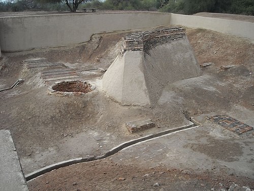
Mound E is the oldest section of area which also has a pre-Harappan settlement underneath. It has a mud brick perimeter wall faced in places with baked bricks. The south wall has a major gateway in the center of a large curve that extends out into the plain seemingly encompassing a public space on the outside. The wall here is 9-11 meters wide if the existence of bastions is considered. The gate is made of baked brick of 1-meter thickness bonded to the mud brick city walls. The possible existence of stairs is in evidence here and the opening is only 2.8 meters wide, just enough for one ox cart to pass through which shows the defensive nature of the gate. It probably stood between 3-4 meters high and had rooms and lookout posts on the top.
A large open area inside the gateway was probably a staging area for checking or taxing of goods or a public market for out of town traders. A large street to the east of the gateway leads north to the center of the city where evidence of workshops of agate, shell, and copper works are found.
Thirty meters due south of the main mound gateway is a small mound of the Harappan period with houses, drains, bathing areas, and a possible well, which probably served as an externally placed traveler's stop for incoming caravans. Even the modern road exists adjacent to this location showing that it possibly lies on the same ancient route as the Harappans used 4500 years ago, and a caravanserai of modern times is also found next to this road and opposite to the Harappan one. The ancient well and bathing platforms were still used in recent historical times as well.
Between Mound E and ET is the second gateway of Mound E. Although the gate here is only 2.6 meters wide, the bastions to either side are a massive 25 meters across and 15 meters deep showing heavy defensive nature of the construction. This controlled access to the main workshop areas of Mound E and also faced the smaller Mound ET that was again another caravanserai for traders engaging in trade with this area.
Only the walls around mound AB have been properly excavated and these were 14 meters wide at the base and larger and higher than the ones of Mound E. These were faced with baked bricks and tapered 11 meters high above the plain level. Gates from 3 different periods are in evidence in the West wall originally excavated by Mortimer Wheeler and a gate in the North wall has a ramp that leads to the smaller Mound F, which itself is strewn with what appear to be house structures and a large building with multiple rooms that might be a granary, great hall or palace. The Citadel has an exact size of 460 yards north-south and 215 yards east to west. It is higher on the north side with the summit at 45-50 ft above the plain. The buildings inside are raised on a mud and mud brick platform 25ft. or so above the former ground level.
Working platforms and craft debris is also found. This mound is also enclosed in the same manner as Mound ET.
These Mounds, although belonging to varying periods, still formed part of the same overall culture and were related to each other in that the same people occupied them, the same type of artifacts are found in them and they were directly connected to each other although why they were made as separate mounds and not as a part of a continuous city cannot be said as of now.
Although there are some indications as to the defensive nature of the walls, this cannot be taken as a certainty due to some missing elements that were known to exist in other defensive walls of the era such as those at Dholavira which had moats and two to three walls instead of just one. These walls were hence probably more to control the trade within the city and make sure it occurred exactly as the administrators of the city wanted. This is further evidence of the control the authority had and how architectural techniques were used by the city to safeguard its interests.
Streets & External Drainage
The most prominent feature of the Harappan era architecture is the drainage system. It shows how important cleanliness was for them, and it was achieved through having a series of drains running along the streets that connected to larger sewers in the main streets. Smaller drains from household latrines and bathing areas connected to these larger drains, which had corbelled roofs so they could be buried underneath the main streets when required without caving in. Some sections had removable brick paving or dressed stones on top to allow cleaning when required. Drains exiting the city even had wooden doors that were probably closed at night to prevent vagrants or negative elements from entering the city through that access. Sump pits were found at intervals along the drains which allowed heavier solid waste to collect at the bottom. These were regularly cleaned to avoid blockages. There is evidence in some places of drains being blocked for a long period of time, possibly 100 to 150 years, after which new drains were made by a new incoming authority. Coupled with this new construction the entire street level ended up rising to the extent that after consecutive re-constructions, entire stories of buildings had to be covered over and the ground level raised in order to bring it on par with the new street so there wouldn't be sewage backflow.
Mound AB contains a large gable-roofed drain with a spill water jar. Another drain is made of a solid mass of bricks with a sharp gradient with polished bricks on the edge as well.
Houses
Varying types of houses and buildings are found in both large and small settlements. Rural areas tend to have exclusively mud brick buildings whereas urban areas have buildings partially or wholly made of baked bricks. Small and large houses and public buildings are the main categories.
Houses range from 1-2 stories in height, with a central courtyard around which the rooms are arranged. The interior is not visible from the street, shut off using corridors or walls in the inside. Openings are also restricted to side streets to maintain privacy on the inside of the houses. Stairs led to the upper stories through a side room or the courtyard and the size of foundations has shown that a third floor might also have existed at one point. The average thickness of walls was 70cm and the average ceiling height about 3 meters. Doors were made of wood with wooden frames and the pivot was a brick socket set in the threshold. Door frames were possibly painted and simply ornamented and also had holes at the base and two at the top of the door to secure and hang curtains respectively. The windows had both shutters and grills, which were embedded into the building itself. Grills might have been of reed or matting but alabaster and marble latticework has also been found suggesting that although it was a common feature of houses, the more refined ones were obviously kept for the more affluent homes. This element continued to be used through historical era into modern times as well.
Larger houses had smaller dwellings connected to them and evidence of repeated rebuilding in the interior shows that the internal spaces were constantly reorganized. Whether the adjoining dwellings were for extended family or servants cannot be accurately ascertained at this time.
Large public buildings are the third major category and include both public spaces such as markets, squares and courtyards, and administrative buildings including granaries. The great hall or great bath structures are also a part of this serving possibly a religious as well as a social function.
Groups or clusters of houses are also in evidence, which probably housed several families together and had their own facilities such as latrines and bathing areas as opposed to using the communal facilities.
Although well planned, they are not as impactful as the houses of other cities due to floods and brick robbery which has left the buildings in a sorry state. Mound F has two nearly complete houses with courtyards and rooms and an angled entrance for privacy along with a latrine as well and a central dividing lane. Fifteen units of workmen's quarters have been found and this complex was surrounded by a wall.
Wells & Sanitation
Drinking water or water, in general, was made available in abundance to the people of Harappa to the very close proximity of the city to the pre-Indus Gaggar/Hakra River which allowed fewer water wells to serve the people as the majority could attain their water from the river itself. There is also found in Harappa a central depression that might have been a public pool for drinking and washing which allowed wider access to the resource. As a result, there are a few wells at Harappa totaling perhaps a total of only 30 wells as compared to 700 or more at Mohenjo-daro. Only 8 have so far been found and the total number of wells has been projected by their layout. There are more private than public wells, which points to the fact that the public wells probably got polluted or run out due to heavy use and affluent citizens then dug their own. Bathing rooms in these houses were situated next to the well which itself was raised above ground level. Bathing rooms had tightly fitted brick floors which made them more or less waterproof. Drains from these rooms led separately to the main drains on the outside from the latrine drains, and care was taken to separate the water and sewage drains. The drains were tapered out into the street. Almost every house in Harappa has been found to contain a latrine which was a large terracotta jar sunk into the ground and sometimes connected to the external drains. A small hole in the bottom of the jar allowed water to seep out to the ground. A special class of laborers probably periodically cleaned these rooms.
Public Buildings
What is proposed to be a granary is located on Mound F, lying on a massive mud brick foundation with a rectangular plan of 50m x 40m, with the length corresponding to the North-South axis. The foundations point to a total of 12 rooms in two rows (6 rooms per row) divided by a central passageway that is 7m wide and partially paved with baked bricks. Each room measures approx. 15m x 6m and has three walls at the long ends with air between them pointing to hollow floors. The main structure would probably have been of wood build on these foundations with stairs leading up from the central path. There have also been found triangular openings in the floor which might have been air ducts to remove moisture from the inside. The evidence for this being a granary has not been found during excavations and is mostly based on comparisons with Roman building techniques and does not coincide with local traditions. Grain is kept in large jars raised from the ground in South Asia and not in rooms as proposed here, and the circular platforms near the buildings thought to be for husking of wheat are found in many other places and spread over a considerable amount of time showing that their function was probably not for agricultural use. Hence it can be said that this “granary” was probably a public or state building for rulers or administrators or for other purposes related to the everyday workings. Due to the lack of any single monumental structure in the cities, we can say that the cities themselves were monumental in an otherwise rural environment.
Building Materials
The main materials used were sun-dried and burnt bricks, which were made in molds of 1:2:4 ratios. Easy availability of wood for burning meant baked bricks were used in abundance in Harappa and Mohenjo-daro. Mud mortar and gypsum cement are also in evidence, and mud plaster and gypsum plaster are also found to have been used. Mud mortar is most evident at Harappa. Wooden frames were probably used for the doors and windows which have since rotted away.
Concluding Words
Although relatively little data has been found at Harappa as compared to other sites of the Indus Valley, it nonetheless holds the distinction of being considered the first identified site of the IVC and hence is still a major site in terms of excavations. The data still being discovered from there is helping us to piece together its history bit by bit, even in the absence of a complete structure such as those at other cities, but this makes the work at Harappa that much more intriguing, in that the archaeologist must connect the pieces like a puzzle to create a whole picture. No doubt much more work needs to be done to preserve the heritage from this most important of sites due to the heavy encroachment and wear and tear it is witnessing in this day and age.